| 43 records found in wikipedia | |||
| 1 | 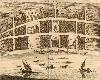
| Thoothukudi  FeatureType : city Elevation : 7 Lat/Lng : 8.8053 / 78.1447 | Tuticorin, known officially as Thoothukudi (Tamil: தூத்துக்குடி), is a port city and a municipal corporation and an industrial city in Thoothukudi district in the Indian state of Tamil Nadu. The city lies in the Coromandel Coast of Bay of Bengal (...) |
| 2 | 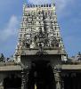
| Rameswaram FeatureType : null Elevation : 10 Lat/Lng : 9.2885 / 79.3127 | Rameswaram, (also spelt as Ramesvaram, Rameshwaram) is a town and a second grade municipality in the Ramanathapuram district in the South Indian state of Tamil Nadu. It is on Pamban Island separated from mainland India by the Pamban channel and is about 40 kilometres from Mannar Island, Sri Lanka (...) |
| 3 | 
| Bay of Bengal FeatureType : waterbody Lat/Lng : 15.0 / 88.0 | The Bay of Bengal (Bengali: বঙ্গোপসাগর) is the northeastern part of the Indian Ocean, bounded on the west and northwest by India on the north by Bangladesh, and on the east by Myanmar and the Andaman and Nicobar Islands of (India) (...) |
| 4 | 
| Kanyakumari FeatureType : null Elevation : 47 Lat/Lng : 8.084 / 77.546 | Kanyakumari (Tamil: கன்னியாகுமரி; pronunciation) is a city of Kanyakumari district in the Indian State of Tamil Nadu. Also, called as the "God's own district". The name comes from the Devi Kanya Kumari Temple in the region, in Tamil it is pronounced as 'Kan-niya-kumari' (...) |
| 5 | 
| Adam's Bridge FeatureType : landmark Lat/Lng : 9.121 / 79.5217 | Adam's Bridge (; Sinhala: adamgay palama), also known as Rama's Bridge or Rama Setu (Sanskrit:),also spelled Rama Setu, Ram Sethu, Ramasethu and variants. is a chain of limestone shoals, between Pamban Island, also known as Rameswaram Island, off the south-eastern coast of Tamil Nadu, India, and (...) |
| 6 | Gulf of Mannar FeatureType : null Lat/Lng : 8.4142 / 78.9894 | The Gulf of Mannar is a large shallow bay forming part of the Laccadive Sea in the Indian Ocean. It lies between the southeastern tip of India and the west coast of Sri Lanka, in the Coromandel Coast region. The chain of low islands and reefs known as Ramsethu, also called Adam's Bridge, which (...) | |
| 7 | Laccadive Sea FeatureType : waterbody Lat/Lng : 6.3 / 76.533 | The Laccadive Sea or Lakshadweep Sea is a body of water bordering India (including its Lakshadweep islands), the Maldives, and Sri Lanka. It is located to the southwest of Karnataka, to the west of Kerala and to the south of Tamil Nadu (...) | |
| 8 | Tamil Nadu FeatureType : adm1st Elevation : 6 Lat/Lng : 13.09 / 80.27 | Tamil Nadu (Tamiḻ Nāḍu "Tamil Country", formerly Madras State) is one of the 29 states of India. Its capital and largest city is Chennai (formerly known as Madras). Tamil Nadu lies in the southernmost part of the Indian subcontinent and is bordered by the union territory of Puducherry and the South (...) | |
| 9 | Gulf of Mannar Marine National Park FeatureType : null Lat/Lng : 9.101 / 78.7272 | The Gulf of Mannar Marine National Park is a protected area of India consisting of 21 small islands (islets) and adjacent coral reefs in the Gulf of Mannar in the Indian Ocean. It lies 1 to 10 km away from the east coast of Tamil Nadu, South India for 160 km between Thoothukudi (Tuticorin) and (...) | |
| 10 | Ramanathapuram district FeatureType : null Elevation : 171 Lat/Lng : 9.2804 / 77.4336 | Ramanathapuram District is an administrative district of Tamil Nadu state in southern India. The town of Ramanathapuram is the district headquarters. Ramanthapuram District has an area of 4123 km2. It is bounded on the north by Sivaganga District, on the northeast by Pudukkottai District, on the (...) | |
| 11 | South India FeatureType : null Elevation : 759 Lat/Lng : 13.0 / 77.0 | South India is the area including the Indian states of Andhra Pradesh, Karnataka, Kerala, Tamil Nadu and Telangana as well as the union territories of Lakshadweep, Andaman and Nicobar Islands, and Puducherry, occupying 19% of India's area (...) | |
| 12 | Thoothukudi district FeatureType : null Elevation : 10 Lat/Lng : 8.803 / 78.1445 | Thoothukudi District, also known as Tuticorin District (தூத்துக்குடி மாவட்டம், Tūttukkuţi Māvaţţam) is a district in Tamil Nadu state in southern India. The district was formed by dividing Tirunelveli district in 1986 and Thoothukudi is the district headquarters (...) | |
| 13 | Geography of India FeatureType : country Elevation : 339 Lat/Lng : 21.0 / 78.0 | India lies on the Indian Plate, the northern portion of the Indo-Australian Plate, whose continental crust forms the Indian subcontinent. The country is situated north of the equator between 8°4' to 35°3' north latitude and 68°7' to 97°25' east longitude.India Yearbook, p (...) | |
| 14 | Kanyakumari district FeatureType : null Elevation : 7 Lat/Lng : 8.078 / 77.541 | Kanyakumari district is the southernmost district in Tamil Nadu state and mainland India. It is also called as the "God's own district". It stands second in terms of population density among the districts of Tamil Nadu and the second most urbanized, next only to Chennai district (...) | |
| 15 | Tamil Eelam FeatureType : null Elevation : 103 Lat/Lng : 8.75 / 80.5 | Tamil Eelam (tamiḻ īḻam, generally rendered outside Tamil-speaking areas as தமிழ் ஈழம்) is a proposed independent state that Tamils in Sri Lanka and the Sri Lankan Tamil diaspora aspire to create in the north and east of Sri Lanka (...) | |
| 16 | Erwadi FeatureType : null Elevation : 10 Lat/Lng : 9.2082 / 78.7101 | Ervadi or Erwadi is a village in Ramanathapuram district, Tamil Nadu in southern India belonging to Kilakkarai Taluk and Keelakarai Town panchayat. The village is the location of the grave and shrine of Qutbus Sultan Syed Ibrahim Shaheed Badusha, the then ruler of Madinah Al Munawwara (...) | |
| 17 | Thamirabarani River FeatureType : null Lat/Lng : 8.6413 / 78.1273 | The Thamirabarani River (Porunai) is a perennial river that originates from the Agastyarkoodam peak of Pothigai hills of the Western Ghats, above Papanasam in the Ambasamudram taluk. It flows through Tirunelveli and Tuticorin districts of the Tamil Nadu state of southern India into the Gulf of (...) | |
| 18 | Kilakarai FeatureType : null Elevation : 13 Lat/Lng : 9.2314 / 78.7844 | Kilakarai, Kilakkarai or Keelakarai is a municipality in Ramanathapuram district in the Indian state of Tamil Nadu. As of 2011, the town had a population of 38,355. Kilakarai is one of the Taluka in Ramanathapuram District. It is also called as Kutti Singapore. (...) | |
| 19 | Sethusamudram Shipping Canal Project FeatureType : waterbody Lat/Lng : 9.0939 / 79.5467 | Sethusamudram Shipping Canal Project is a proposed project to create a shipping route in the shallow straits between India and Sri Lanka. This would provide a continuously navigable sea route around the Indian Peninsula (...) | |
| 20 | Protected areas of Tamil Nadu FeatureType : null Elevation : 7 Lat/Lng : 8.125 / 77.4583 | The Protected areas of Tamil Nadu State in South India cover an area of , constituting 2.54% of the geographic area and 15% of the recorded forest area. It ranks 14th among all the States and Union Territories of India in terms of total protected area.Tamil Nadu Forest Dept (...) | |
| 21 | Dhanushkodi FeatureType : city Lat/Lng : 9.152 / 79.4459 | Dhanushkodi is an abandoned town at the south-eastern tip of Pamban Island of the state of Tamil Nadu in India. It is situated to the South-East of Pamban and is about west of Talaimannar in Sri Lanka. The town was destroyed during the 1964 Rameswaram cyclone and remains uninhabited in the aftermath (...) | |
| 22 | Tuticorin Port Trust FeatureType : null Lat/Lng : 8.473 / 78.1215 | V.O.Chidambaranar Port, formerly Tuticorin Port,. The Hindu (28 January 2011). is one of the 12 major ports in India. It was declared to be a major port on 11 July 1974. It is second-largest port in Tamil Nadu and fourth-largest container terminal in India (...) | |
| 23 | Pamban Island FeatureType : isle Elevation : 6 Lat/Lng : 9.2741 / 79.2911 | Pamban Island (Pāmpan Island), also known as Rameswaram Island, is an island located between peninsular India and Sri Lanka. The island is a part of India and forms the Rameswaram taluk of the Ramanathapuram district of the state of Tamil Nadu. It is the largest island in Tamil Nadu by area (...) | |
| 24 | Thoothukudi massacre FeatureType : null Elevation : 13 Lat/Lng : 8.48 / 78.04 | The Thoothukudi massacre (also known as the Thoothukudi mass murder,, Tuticorin massacre or Sterlite Protest Firing) took place on 22 May 2018 in Thoothukudi district, Tamil Nadu, India, When Tamil Nadu Police forces, some of them not wearing uniforms, fired into a crowd of 20,000 people (...) | |
| 25 | Char Dham FeatureType : null Elevation : 3830 Lat/Lng : 30.73 / 79.48 | The Char Dham ("four abodes") is a set of four pilgrimage sites in India. Vaishnavite Hindus believe that visiting these sites helps achieve "Moksha" (salvation). It comprises Badrinath, Dwarka, Puri and Rameswaram (...) | |
| 26 | Nallathanni Theevu FeatureType : isle Elevation : 7 Lat/Lng : 9.1067 / 78.5789 | Nalla Thanni Theevu is an island situated in the Gulf of Mannar about 4 kilometers south-east of the coast of Tamil Nadu, India. It is one of the three inhabited islands in the Gulf of Mannar the others being Krusadai Island and Muyal Island (...) | |
| 27 | Periyapattinam FeatureType : null Elevation : 8 Lat/Lng : 9.2726 / 78.9023 | Periyapattinam is a large village located in the eastern part (Gulf of Mannar) of Ramanathapuram district, Tamil Nadu, India. The inhabitants of this village are primarily Tamil Muslims (...) | |
| 28 | Hare Island FeatureType : isle Lat/Lng : 8.7744 / 78.1979 | Hare Island is an island which lies adjoining the Tuticorin port. It is a very good picnic spot for holiday seekers and the domestic tourist. Many tourists visit here during the Pongal holidays when special buses are operated for the benefit of the tourists (...) | |
| 29 | Kayalpatnam FeatureType : null Elevation : 4 Lat/Lng : 8.5714 / 78.1199 | Kayalpatnam (also known as Kayalpattinam or Kayalpattanam Arabic - قاهر فطن, Tamil - காயல்பட்டினம்) is a Municipality in Thoothukudi district in the Indian state of Tamil Nadu. As of 2011, the town had a population of 40,558. (...) | |
| 30 | Kulasekharapatnam FeatureType : null Elevation : 8 Lat/Lng : 8.3998 / 78.0514 | Kulasekarapatnam (Kulasekharapattinam, Tamil – குலசேகரப்பட்டிணம்) is a town in the Thoothukudi district (formerly Tinnelvelly or Tirunelveli) of Tamil Nadu, India. Kulasekharapatnam was an ancient port dating to the 1st centuries of the Christian era and was contemporaneous to the existence of (...) | |
| 31 | National Institute of Ocean Technology FeatureType : null Elevation : 3 Lat/Lng : 12.9467 / 80.211 | The National Institute of Ocean Technology (NIOT) was established in November 1993 as an autonomous society under the Ministry of Earth Sciences, Government of India. NIOT is managed by a Governing Council and the Director is the head of the Institute. The institute is based in Chennai (...) | |
| 32 | Uchipuli FeatureType : null Elevation : 8 Lat/Lng : 9.3167 / 79.0167 | Uchipuli or Uchippuli is a locality in the Mandapam block of Ramanathapuram district, Tamil Nadu, India. It is a major source of water supply for the Ramanathapuram town. An Indian Navy air station, INS Parundu, is located near Uchipuli. (...) | |
| 33 | INS Parundu FeatureType : null Elevation : 7 Lat/Lng : 9.3239 / 78.9728 | INS Parundu is an Indian naval air station located near Uchipuli in the Ramanathapuram district of the state of Tamil Nadu. It operates under the Eastern Naval Command of the Indian Navy. The air station will be opened up for civilian flights under Phase 2 of the Regional Connectivity Scheme (RCS) (...) | |
| 34 | Devipattinam FeatureType : null Elevation : 7 Lat/Lng : 9.477 / 78.8961 | Devipattinam is a coastal village of Ramanathapuram district.,http://tnmaps.tn.nic.in/blks_info.php?dcode=27&blk_name=Ramanathapuram&dcodenew=23&drdblknew=2 Tamil Nadu, India. Devipattinam is an ancient coastal town and a port, located in the southern state of Tamil Nadu (...) | |
| 35 | Chitrangudi Bird Sanctuary FeatureType : null Elevation : 23 Lat/Lng : 9.3228 / 78.4867 | Chitrangudi Bird Sanctuary locally known as "Chitrangudi Kanmoli" is a Protected area declared in 1989 and a part of Chitrangudi village, Mudukulathur Taluk, Ramanathapuram District, Tamil Nadu, India. It is adjacent to Kanjirankulam Bird Sanctuary (...) | |
| 36 | Kothandaramaswamy Temple FeatureType : landmark Elevation : 3 Lat/Lng : 9.2333 / 79.348 | The Kothandaramaswamy Temple at Rameswaram, Tamil Nadu is a shrine dedicated to the Hindu deity Rama. Located at a distance of from Rameswaram, it forms the southernmost tip of the island. The temple is the only historical structure to survive the 1964 cyclone that washed away Dhanushkodi (...) | |
| 37 | Pudumadam FeatureType : null Elevation : 11 Lat/Lng : 9.277 / 78.9938 | Pudumadam is a village in Ramanathapuram district in the Indian state of Tamil Nadu. It is located of National Highway 47 in road Rameshwaram. Pudumadam is 4 km from Uchippuli which is on the National Highway 49 (NH 49). NH 49 runs from Kochi to Rameswaram (...) | |
| 38 | Tharuvaikulam FeatureType : null Elevation : 9 Lat/Lng : 8.895 / 78.166 | Tharuvaikulam is a Village in Thoothukudi District of Tamil Nadu, South India. There are about 3000, mostly Catholic families living there. It boasts of some of the best Prawn hatcheries and Salt Pans in Tamil Nadu. It falls under the Roman Catholic diocese of Thoothukudi and the feast of St (...) | |
| 39 | Vembar FeatureType : null Elevation : 11 Lat/Lng : 9.0816 / 78.363 | Vembar is a village panchayat in Thoothukudi district in the Indian state of Tamil Nadu. Vembar is a village situated along the East Coast road at the north end of Tuticorin district. It has two Panchayets - Vembar and Vembar South (...) | |
| 40 | Nambiyar River FeatureType : river Lat/Lng : 8.2333 / 77.8 | The Nambiyar river runs across Nanguneri taluk in Tirunelveli district in Tamil Nadu state in India. It is a small river which runs for only . The river originates from near Thirukkurungudi village in the Western Ghats, about above sea level, and ends at the Gulf of Mannar. (...) | |
| 41 | Valinokkam FeatureType : city Lat/Lng : 9.1667 / 78.65 | Valinokkam is a village in Ramanathapuram district in Tamil Nadu. Because it is near the seashore, Valinokkam is famous for salt production. The Tamil Nadu Salt corporation started Salt production from Valinokkam in the year 1974.http://www.tnsalt.com/ (...) | |
| 42 | Kanjirankulam Bird Sanctuary FeatureType : null Elevation : 26 Lat/Lng : 9.3333 / 78.4833 | Kanjirankulam Bird Sanctuary is a Protected area near Mudukulathur Ramanathapuram District, Tamil Nadu. India, declared in 1989. . It is adjacent to Chitrangudi Bird Sanctuary. It is notable as a nesting site for several migratory heron species that roost in the prominent growth of babul trees there (...) | |
| 43 | Upputanni Island FeatureType : null Elevation : 6 Lat/Lng : 9.0906 / 78.4914 | Upputanni is an uninhabited island situated in the Gulf of Mannar. It is located at a distance of about from the coast of Tamil Nadu, India and is a part of the Kadaladi taluk of Ramanathapuram district, Tamil Nadu (...) | |
 by
by